

These Are The Best Images Of The Year From Some Of The World’s Most Powerful Commercial Satellites
DigitalGlobe
DigitalGlobe, a commercial satellite imaging company, has just released a breathtaking collection of its 25 best images from the year.
The images reflect the many uses of modern satellite technology, including its ability to monitor global operations, like mining or farming, keep track of natural disasters, record human conflicts, and contribute to scientific research.
Among these are a handful of images from the company’s newest satellite, WorldView-3, which launched in August and, according to DigitalGlobe, delivers its highest-quality products.
The company is asking fans to vote for their favorite birds-eye views of Earth on its Facebook page.
The top five images with the most “likes” will make it to the final round later this month. The website will announce the winning image in early January 2015.
Check out all of the images here, then head over to the Facebook album to vote for your favorite.
Satellites are often used to monitor the environment, as they can show widespread changes in habitats over time, like deforestation. This image is of the forested countryside of Alberta, Canada, shown Oct. 10, 2014.

This is Nordenskjold Basin in Antarctica on March 12, 2014. Frozen areas like this can be monitored by satellite in order to observe whether the ice is melting and assess the impacts of climate change.

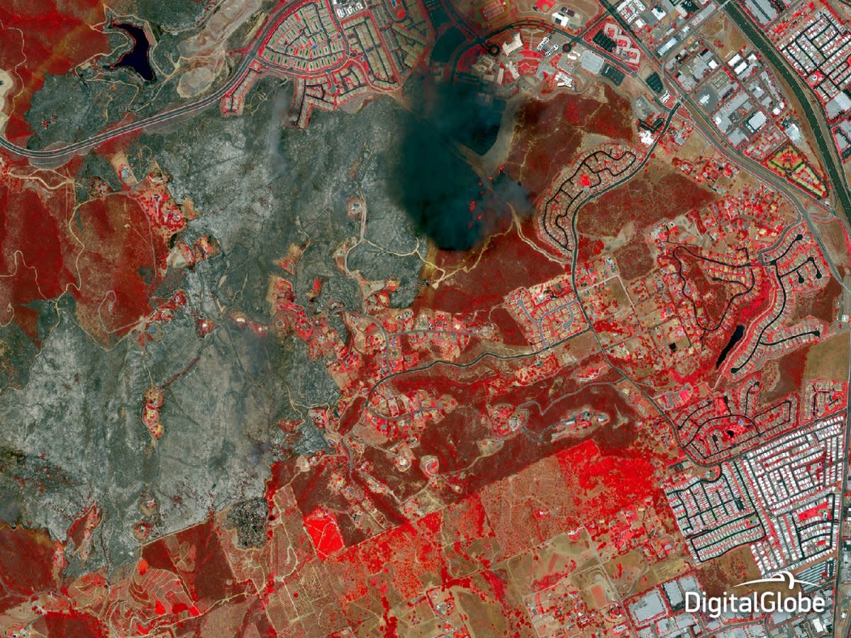
Natural disasters, like these wildfires in San Diego County, Calif., are another environmental phenomenon often best observed from higher up. This image was taken on May 15, 2014.

Similarly, here’s a view of the erupting Mount Sinabung in Indonesia on Jan. 23, 2014. First responders can use such images to assess damage and help create evacuation plans.
Such information is useful in situations like this flooding in Gunja, Croatia on May 21, 2014.

Urban planning is a tough job, especially in big cities where it’s hard to get an accurate sense of the layout from the ground. Peering down from space gives a better impression of such areas, like these densely packed neighborhoods in Mexico City, captured on Aug. 1, 2014.

Social events are easy to observe from afar. Here’s Oktoberfest in Munich, Germany on Sept. 24, 2014 — an event attended by millions of people each year.

The same goes for the Glastonbury Festival, a five-day music festival attended by about 200,000 people, in Somerset, England on June 25, 2014.

Other special kinds of imaging can help geologists identify mineral deposits, like the ones here at Cuprite Hill, Nevada. The four sections in this image, taken Sept. 19, 2014, show different spectral band combinations used to identify deposits in the Earth.

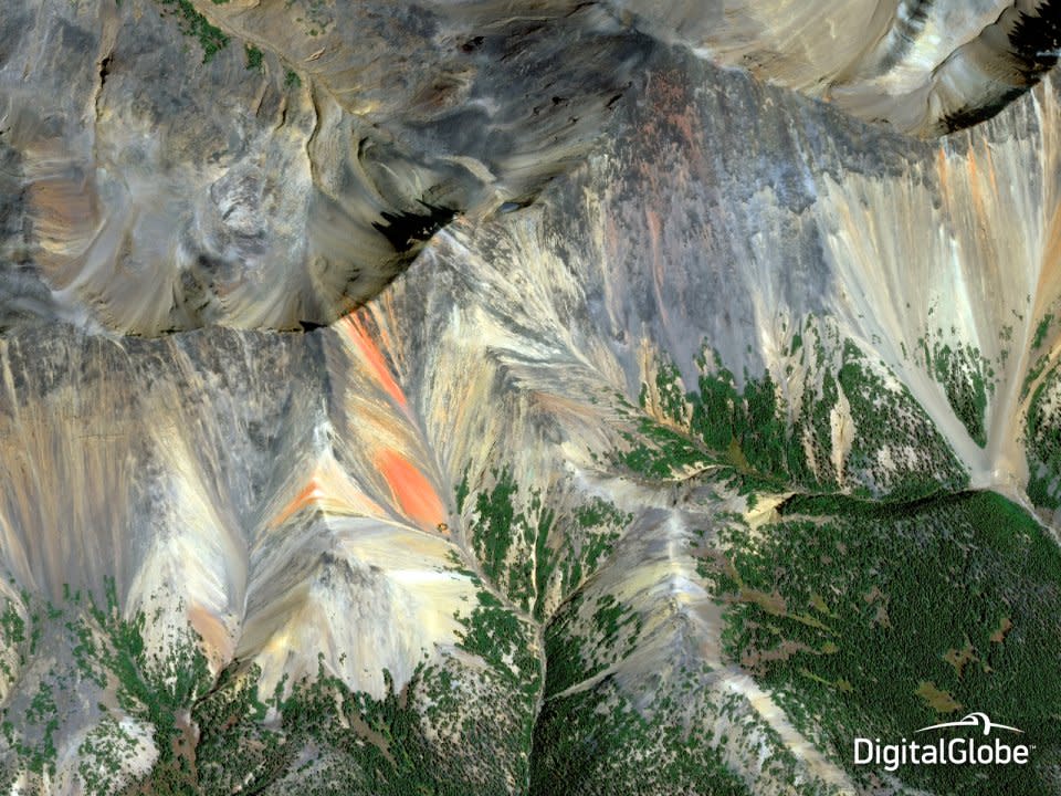
Here’s another striking image of mineral deposits. This is Rainbow Range, a mountain range known for its colorful, mineralized bands of volcanic lava and sand, in British Columbia, Canada on Sept. 20, 2014.
Satellite images aren’t all fun an games, though. They are useful for many other reasons. This is the Bayan Obo Mining District in China, captured Aug. 23, 2014. Satellite imagery can help keep track of mine productivity from afar.

Here’s another mine, the Henan Coal Mine in China, captured May 29, 2014. Satellites can record fuel levels and emissions from mines like this one to help monitor their environmental impacts.

And here’s a slightly different type of mine: the Diavikk Diamond Mine in Canada, seen on Aug. 21, 2014.

Satellites are also capable of using different types of imagery to make observations about a location. Near infrared and shortwave infrared imagery can provide information about aquaculture, like the amount and types of vegetation. These are fisheries in the waters off Huayuanli, China, captured Oct. 18, 2014.

This image of Kiev, Ukraine, illustrates the power of remote imaging to capture scenes of human conflict. Kiev has been the site of escalating protests since last year. This image was taken Feb. 24, 2014.

More human conflict is hauntingly captured in this image of Iraqi refugees traveling from the city of Sinjar to escape Islamic militants on Sept. 15, 2014.

A big-picture look at such conflicts can help international bodies and aid organizations make decisions about how to help displaced people and suffering communities. One city that has seen it share of conflict is Kobane, Syria, pictured here Nov. 6, 2014.

Even the commercial sector can benefit from certain satellite applications. For instance, this image shows a shipping yard in Garden City, Georgia, on May 16, 2014. Analysts can look at the number and type of shipping containers and use this information to make assessments about the economy.

Here, an image of the airport at Everett, Washington from July 26, 2014 can reveal types of aircraft, cargo, and other important operational information.

These are the Spui Locks at IJmuiden, Netherlands on Aug. 27, 2014. Monitoring civil infrastructure components like these locks can help governments keep track of local operations.

Rail yards are another civil operation satellites can help monitor. This is a rail yard in Maschen, Germany on Aug. 6, 2014.

Objects in the middle of the ocean can be hard to access regularly, so observing them via satellite can be helpful in the way of monitoring conditions and checking on equipment. Here’s one example: an oil facility in the Caspian Sea, off the coast of Kazakhstan , seen September 2014.

And here’s a similarly isolated site: the Prirazlomnaya Oil Platform off the coast of Russia on June 28, 2014.

Waste management is another important environmental consideration. This image reveals the world’s largest tire graveyard in Sulaibiya, Kuwait , pictured on June 4, 2014.

And evaluating the environmental impacts of construction projects is no less important. For example, remote sensing can help developers figure out how the Itaipu Dam in Paraguay, shown here on March 12, 2014, is affecting the water and the communities that depend on it.

Looking for more great satellite images?

Check out these mind-blowing images of Earth from space>>
Read more stories on Business Insider, Malaysian edition of the world’s fastest-growing business and technology news website.

